Page 4 - WS_BND
P. 4

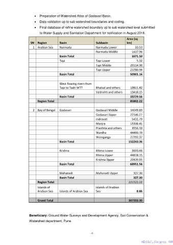
•  Preparation of Watershed Atlas of Godavari Basin.
                         •  Data validation up to sub watershed boundaries and coding.

                         •  Final database of refine watershed boundary up to sub watershed level submitted
                            to Water Supply and Sanitation Department for notification in August 2018.

                                                                                        Area (sq
                      SN  Region          Basin                    Subbasin             km)
                        1  Arabian Sea    Narmada                  Narmada Lower              33.53
                                                                   Narmada Middle           1637.96
                                          Basin Total                                       1671.50
                                          Tapi                     Tapi Lower                  5.32
                                                                   Tapi Middle             29114.90
                                                                   Tapi Upper              21780.94
                                          Basin Total                                      50901.16

                                          West flowing rivers from
                                          Tapi to Tadri WTT        Bhatsal and others      19811.42
                                                                   Vashishti and others    13418.15
                                          Basin Total                                      33229.56
                           Region Total                                                    85802.22

                        2  Bay of Bengal   Godavari                Godavari Middle         34049.83
                                                                   Godavari Upper          22146.27
                                                                   Indravati                5431.79
                                                                   Manjra                  15306.41
                                                                   Pranhita and others      3556.50
                                                                   Wardha                  44460.19
                                                                   Weinganga               27292.37
                                          Basin Total                                     152243.36

                                          Krishna                  Bhima Lower              3693.48
                                                                   Bhima Upper             44818.15
                                                                   Krishna Upper           20439.93
                                          Basin Total                                      68951.56

                                          Mahanadi                 Mahanadi Upper            327.30
                                          Basin Total                                        327.30
                           Region Total                                                   221522.22
                           Islands of                              Islands of Arabian
                           Arabian Sea    Islands of Arabian Sea   Sea                         8.86

                           Grand Total                                                    307333.30


                     Beneficiary: Ground Water Surveys and Development Agency, Soil Conservation &
                     Watershed department, Pune.


                                                               - 4 -

                                                                                                  MRSAC,Nagpur ©®
                                                                                                   MRSAC,Nagpur ©®
   1   2   3   4