
Page 2 - RGNDWM
P. 2
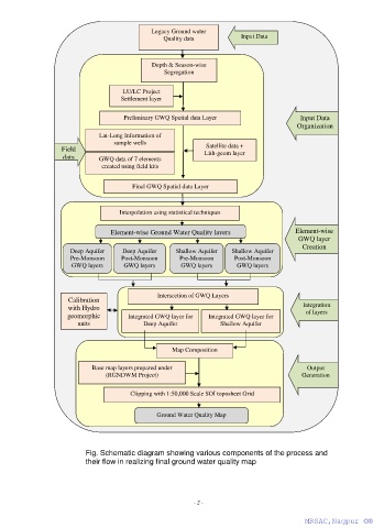
Legacy Ground water
                                                     Quality data             Input Data


                                                 Depth & Season-wise
                                                     Segregation


                                        LU/LC Project
                                        Settlement layer
                                      -

                                         Preliminary GWQ Spatial data Layer                      Input Data
                                                                                                Organization
                                 Lat-Long Information of
                                     sample wells
                                                                   Satellite data +
                     Field                                        Lith-geom layer
                     data        GWQ data of 7 elements
                                 created using field kits


                                           Final GWQ Spatial data Layer


                                       Interpolation using statistical techniques


                                    Element-wise Ground Water Quality layers                   Element-wise
                                                                                                GWQ layer
                                                                                                  Creation
                       Deep Aquifer     Deep Aquifer     Shallow Aquifer   Shallow Aquifer
                       Pre-Monsoon      Post-Monsoon      Pre-Monsoon       Post-Monsoon
                        GWQ layers       GWQ layers        GWQ layers        GWQ layers


                                                   Intersection of GWQ Layers
                       Calibration
                       with Hydro                                                                 Integration
                       geomorphic         Integrated GWQ layer for   Integrated GWQ layer for      of layers
                          units                Deep Aquifer            Shallow Aquifer


                                                        Map Composition

                              Base map layers prepared under                                       Output
                                   (RGNDWM Project)                                              Generation


                                           Clipping with 1:50,000 Scale SOI toposheet Grid


                                                   Ground Water Quality Map


                            Fig. Schematic diagram showing various components of the process and
                            their flow in realizing final ground water quality map


                                                               - 2 -

                                                                                                  MRSAC,Nagpur ©®
                                                                                                   MRSAC,Nagpur ©®