
Page 5 - CIDCO
P. 5
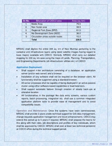
Sr.No.        Bifurcation of CIDCO area               Area (sq. km)
                             1.    Nodal Area                                        79.5

                             2.    Non Nodal area                                    38.5
                             3.    Regional Park Zone (RPZ)                          61.5
                             4.    No Development Zone (NDZ)                         36.0
                             5     Circulation areas outside nodes                   15.0
                                   Total                                            230.5


                   MRSAC  shall  digitize  the  entire  344  sq.  km  of  Navi  Mumbai  pertaining  to  the
                   cadastral and infrastructure layers using latest satellite images having regard to
                   base  map(s)  available  with  CIDCO.  Similarly,  MRSAC  shall  carry  out  detailed
                   mapping for 230 sq. km area using the maps of Lands, Planning, Transportation,

                   and Engineering Departments (all infrastructure/ utilities etc.) of CIDCO

                   Application Deployment:
                   •    Shall  support  n-tier  architecture  consisting  of  a  database,  an  application
                        server (and/or web server) and a browser.
                   •    Installation of any software shall not be required on the browser client. All
                        functionality shall be supported using a standard browser.
                   •    All server processes shall be capable of being deployed in an active-passive

                        cluster using either software-based capabilities or load balancers.
                   •    Shall  support  automatic  failover  through  creation  of  steady  back-ups  at
                        alterative location.
                   •    All  functionalities  in  the  package  like  data  entry  screens,  various  custom
                        reports,  batch  processing,  integration  etc.  shall  use  a  common  integrated
                        application  platform  suite  to  provide  ease  of  management  and  to  avoid
                        compatibility issues.

                   Operation  and  Maintenance:  Once  the  systems  have  been  commissioned,
                   MRSAC shall provide 3 years onsite technical support for GIS data management,
                   change requests application management and future enhancements. CIDCO may
                   extend this period up to 5 years if required. MRSAC shall propose the teams for
                   this along with their roles, job descriptions and profiles of key individuals, which

                   shall be approved by CIDCO. MRSAC shall post at least two technical personnel
                   at CIDCO office during the technical support period.


                                                                                                      MRSAC,Nagpur ©®
                                                                                                      MRSAC,Nagpur ©®