Page 4 - NUIS
P. 4

The  non-spatial  (attribute  or statistical) data,  broadly  include urban
                   infrastructure  (transportation),  housing,  demography,  socio-economic,
                   utilities, environment and land use. The land use includes details of urban
                   land use of residential, public/semi-public and so on.


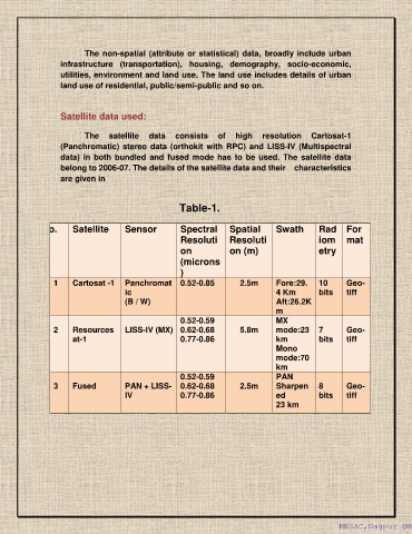
                   Satellite data used:

                          The  satellite  data  consists  of  high  resolution  Cartosat-1
                   (Panchromatic)  stereo data  (orthokit with  RPC)  and  LISS-IV  (Multispectral
                   data) in  both bundled  and fused mode  has  to  be  used.  The satellite  data
                   belong to 2006-07. The details of the satellite data and their    characteristics
                   are given in


                                                      Table-1.

         Sr. No.       Satellite      Sensor           Spectral  Spatial           Swath        Rad     For
                                                       Resoluti      Resoluti                   iom     mat
                                                       on            on (m)                     etry
                                                       (microns
                                                       )
                 1     Cartosat -1  Panchromat         0.52-0.85        2.5m       Fore:29.     10      Geo-
                                      ic                                           4 Km         bits    tiff
                                      (B / W)                                      Aft:26.2K
                                                                                   m
                                                       0.52-0.59                   MX
                 2     Resources      LISS-IV (MX)  0.62-0.68           5.8m       mode:23      7       Geo-
                       at-1                            0.77-0.86                   km           bits    tiff
                                                                                   Mono
                                                                                   mode:70
                                                                                   km
                                                       0.52-0.59                   PAN
                 3     Fused          PAN + LISS-      0.62-0.68        2.5m       Sharpen      8       Geo-
                                      IV               0.77-0.86                   ed           bits    tiff
                                                                                   23 km


                                                                                                      MRSAC,Nagpur ©®
                                                                                                      MRSAC,Nagpur ©®
   1   2   3   4   5   6   7   8