Page 11 - HEALTH GIS
P. 11

TARGET         TARGET        TARGET
                                                                                                                    I             II            III


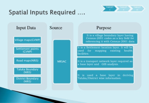
                  Input Data                         Source                                           Purpose


                                                                                            It is a village boundary layer having
                                                                                           Census-2001 codes as a key field for
                Village maps(GVMP)
                                                                                           referencing it with Census-2001 data


                  Settlement points                                               It is a Settlement location layer. It will be
                         (GVMP)                                                   used       for     mapping        existing       health
                                                                                  facilities.


                  Road maps(NRIS)                            MRSAC                It is a transport network layer required as

                                                                                  a base layer and GIS analysis.

                  Taluka Boundary
                          (NRIS)
                                                                                  It is used a base                layer in deriving
                  District Boundary                                               Taluka/District wise information.
                          (NRIS)
   6   7   8   9   10   11   12   13   14   15   16