
Page 15 - HEALTH GIS
P. 15
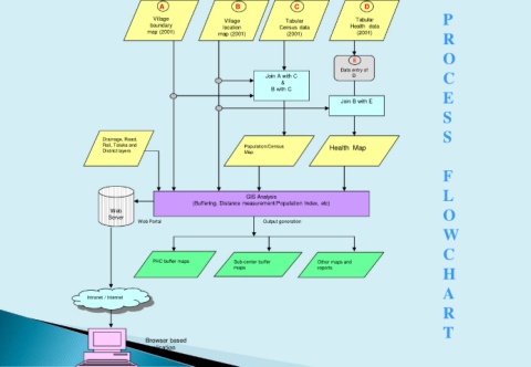
A                     B                 C                   D
                                              Village              Village           Tabular              Tabular                  P
                                             boundary              location        Census data          Health  data
                                            map (2001)           map (2001)          (2001)               (2001)
                                                                                                                                   R

                                                                                                                                   O
                                                                                                         E
                                                                                                     Data entry of
                                                                               Join A with C             D                         C
                                                                                    &
                                                                                 B with C
                                                                                                     Join B with E                 E
                                                                                                                                   S


                                                                                                                                   S
                               Drainage, Road,
                               Rail, Taluka and                          Population/Census        Health  Map
                               District layers                           Map


                                                                                                                                   F

                                                                                                                                   L
                                                                         GIS Analysis
                                                          (Buffering, Distance measurement/Population Index, etc)
                                 Web                                                                                               O
                                 Server
                                          Web Portal                          Output generation
                                                                                                                                   W

                                                                                                                                   C

                                              PHC buffer maps         Sub-center buffer       Other maps and
                                                                                                                                   H
                                                                      maps                    reports
                                                                                                                                   A
                           Intranet / Internet
                                                                                                                                   R


                                                                                                                                   T
                                            Browser based
                                            application