Page 13 - HEALTH GIS
P. 13

Phase I


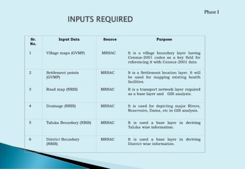
                    Sr.               Input Data                   Source                            Purpose
                    No.

                   1          Village maps (GVMP)                 MRSAC            It is a village boundary layer having
                                                                                   Census-2001 codes as a key field for
                                                                                   referencing it with Census-2001 data


                   2          Settlement points                  MRSAC             It is a Settlement location layer. It will
                              (GVMP)                                               be used for mapping existing health
                                                                                   facilities.

                   3          Road map (NRIS)                    MRSAC             It is a transport network layer required
                                                                                   as a base layer and GIS analysis.


                   4          Drainage (NRIS)                    MRSAC             It is used for depicting major Rivers,
                                                                                   Reservoirs, Dams, etc in GIS analysis.


                   5          Taluka Boundary (NRIS)             MRSAC             It is used a base layer in deriving
                                                                                   Taluka wise information.


                   6          District Boundary                  MRSAC             It is used a base layer in deriving
                              (NRIS)                                               District wise information.
   8   9   10   11   12   13   14   15   16   17   18